The Transmission Assets
The Onshore Transmission Assets Scoping Boundary spans the area from project landfall, between Blackpool and Lytham St Annes, and the National Grid substation at Penwortham, Lancashire.
We are seeking consent for:
- Shared offshore export cable corridors to landfall
- Shared onshore export cable corridors to two new onshore substations
- Onward connection to the National Grid substation at Penwortham.
Offshore infrastructure associated with Transmission Assets includes, but is not limited to, offshore export cables, offshore substation platform(s) and offshore booster station(s).
Because offshore wind farm development and their Transmission Assets can be complex, many of the details of the project are not yet known. This includes:
- Any potential refinements to the proposed landfall area
- The exact location of the proposed new substations, and associated temporary and permanent areas.
- The refined indicative onshore export cable corridor (including associated temporary areas) and the indicative search areas for the location of two new substations are the subject of this non-statutory consultation.
The refined indicative onshore export cable corridor (including associated temporary areas) and the indicative search areas for the location of two new substations were the subject of our non-statutory consultation in 2023.
For further information on our proposals, view the non-statutory consultation materials in our information hub.
Visit our Information HubFast facts: Indicative onshore export cable corridor
The below information is based on current understanding and may be further refined ahead of our statutory consultation later in the year.
- Maximum indicative length of onshore export cable corridor - 35km
- Maximum number of underground export cables - 18
- Maximum indicative width of onshore export cable corridor (temporary) - 120m
- Maximum permanent width of onshore export cable corridor - 80m
Indicative landfall and onshore export cable corridor
We are in the process of refining the route of the onshore export cable corridor which will connect the Morgan and Morecambe offshore wind farms from the project landfall area to the proposed new substation sites.
At the proposed project landfall point, the offshore export cables would be brought ashore before being connected to the onshore export cables. The exact methodology or methodologies are being developed and will be presented at future engagement.
The indicative onshore export cable corridor is the area within which the onshore export cables would be located. The proposed corridor is located within the Onshore Transmission Assets Scoping Boundary, on which we sought feedback during our 2022 non-statutory consultation.
Since then, we have been refining our proposals to produce the indicative onshore export cable corridor on which we invited feedback during our 2023 non-statutory consultation. This feedback will inform our site selection process.
The indicative onshore export cable corridor has a total width of approximately 120m some of which will be used temporarily for construction. Within this area, the permanent onshore export cable corridor of up to approximately 80m will be located. The temporary and permanent width of the onshore export cable corridor may vary slightly where constraints are encountered, such as complex railway crossings and larger horizontal directional drills (i.e. a trenchless drilling technique).
The final cable route is proposed to contain up to 18 export cables, buried in up to six separate circuits. Temporary access tracks, compound and laydown areas have preliminarily been identified to facilitate construction. Permanent access points for operation and maintenance purposes will also be required along the route. However, no permanent infrastructure is expected to be required for these.
As responsible developers, we are committed to designing cable routes with the best interests of communities in mind. We have used the feedback we received at our first consultation – and the results of our ongoing environmental and engineering studies, and discussions with landowners and those with an interest in the land – to refine the process and to determine the indicative onshore export cable corridor shown in this consultation.
During our 2023 non-statutory consultation, we invited your feedback on the refined indicative onshore export cable corridor (and associated temporary areas), alongside the search areas within which we propose to locate our onshore substations. You can see these areas on our map below.
Temporary compound areas
Temporary compounds and laydown areas would also be required to support construction works. Indicative locations for these are indicated on the map below. These would be accessed via temporary access tracks.
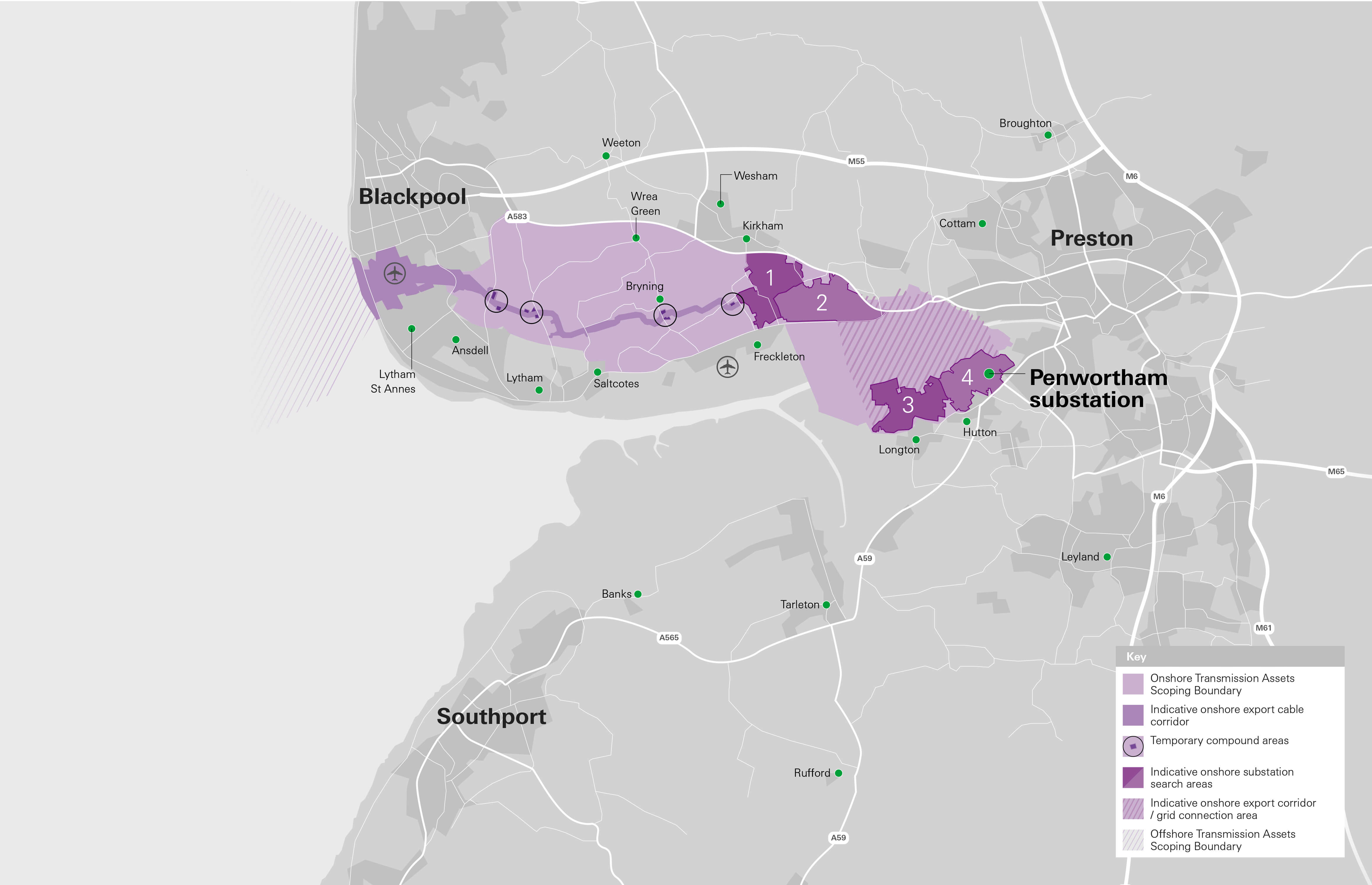
Indicative onshore substation search areas
To connect to the national grid via the point of interconnection (POI) we will need to construct two new onshore substations. These new substations are needed to transform the power generated by the offshore wind farms and to provide a connection to the grid.
During our 2023 non-statutory consultation we presented the four broad indicative substation search areas that are being considered as part of the site selection process for two proposed new substations to connect the Morgan and Morecambe projects to the national grid. In our consultation materials, we presented information on these search areas, and sought feedback to inform our site selection process.
To maintain electrical independence, one substation will be required for the Morgan Offshore Wind Project and one for the Morecambe Offshore Windfarm. We propose to site them within the broad indicative search areas. Please note, the two substations would not occupy the whole of each search area. They are currently anticipated to cover a maximum combined permanent footprint of approximately 280,000m2. The maximum height of the main structure/buildings will be 25 metres. It is likely that screening for substations will be provided through landscaping and planting areas.
The site selection process aims to identify the most suitable locations for the substations, taking into account environmental and engineering constraints such as proximity to residential receptors, designated sites, flood risk and ground conditions. Local and community knowledge and considerations form part of these and are integral to the site selection process.
Four search areas are being considered, all within the Onshore Transmission Assets Scoping Boundary. At each stage of the site selection process only the search areas which perform best against the range of criteria are taken forward to the next stage. During our 2023 non-statutory consultation we invited feedback on our indicative onshore substation search areas. You can see these areas on our map (left).
Where are the indicative onshore substation search areas?
We are asking for your feedback on four indicative onshore substation search areas as part of this consultation:
- Indicative onshore substation search area 1 is an area south east of Kirkham, north east of Freckleton and west of Newtonwith- Scales. It does not include Hall Cross or Kirkham Prison.
- Indicative onshore substation search area 2 is an area south of Newton-with-Scales bordered by the Preston New Road (A584) and the Blackpool Road (A583) to the north east. It does not include Newton Bluecoat Primary School.
- Indicative onshore substation search area 3 is an area south of the River Ribble, north of Longton and west of Hutton. It does not include Hutton and Longton Marshes.
- Indicative onshore substation search area 4 is an area south of the River Ribble,north of Hutton and east of Howick Cross and Penwortham. It includes the existing National Grid Substation near Penwortham.
Indicative onshore export cable corridor / grid connection area
Onshore export cables will be required to connect from the landfall point to the two new substations and onwards to the POI at the existing National Grid substation at Penwortham. The indicative onshore export cable corridor / grid connection area represents the area within which the proposed onshore export cables will link the two new onshore substations to the POI at the National Grid substation.
The final section of export cable corridor/ grid connection area will be dependent on the confirmed substation sites. This may include a section of the onshore export cable corridor or the grid connection area. You can see these areas on our map (above left).
The point of interconnection
The Morgan and Morecambe offshore wind farms are expected to connect to the national grid via an existing substation at Penwortham.
This is known as the point of interconnection (POI) and was identified through a site selection process undertaken by National Grid, who manage the electricity transmission network.